Atlantic Crossing
Goose Bay to Shannon Ireland
The actual flying across the Atlantic was relatively easy. We had reasonable weather with ceilings generally in the marginal VFR to light IFR range. Plenty of wind, however. Landing at Kangerlussuaq we had at least 15 knots of crosswind (20 is the max for the TBM) and at Reykjavik we had winds gusting to 25 knots but not as much crosswind.
Our route from Reykjavik to Shannon took us pretty far to the north, over a waypoint called RATSU. Someone asked me why what is, suspecting that our goal was to get close to land as quickly as possible. While that is certainly a good suggestion, it is not actually the reason we took this route. We needed to stay north and east of RATSU. If we had gone direct to Shannon from Reykjavik, we would have been south and west which would have put us in Shanwick Airspace. Shanwick requires that all aircraft be equipped with HF radio, which we are not (VHF only). So, you fly from Iceland to RATSU and then down to Shannon from there. That keeps you in Scottish airspace.

LAT / LON and Position Reporting
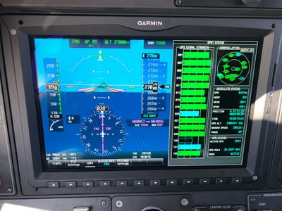
We had to know how to enter a LAT / LON fix into the aircraft's navigational system (G3000) since we had such fixes in our flight plan. On the way from Goose Bay to Kangerlussuaq, one is no longer under radar coverage from the PRAWN fix east. We filed N60.00.00 W057.00.00 and N64.00.00 W055.00.00 as our next two waypoints after PRAWN. These are easily created as User Waypoints in the G3000 and then added the FMS' flight plan.
As we reached these fixes, we needed to make position reports to Gander Radio, reporting our location relative to the fix, the time we crossed it, our altitude, the next reporting point, and our estimated time of arrival at that point. With that data, ATC keeps aircraft clear of one another in this non-radar environment. Unfortunately, since there is no radar, ATC keeps at least 120NM between aircraft through here so you may not get the altitude you want. We crossed on this leg at FL270.
Interestingly, we also got ATC instructions to change frequency to the next controller in the form of, "Contact Gander Radio on 124.40 upon crossing WEST 56.” So, we kept the G3000 on the display in the photo so we knew when we crossed that longitude.
Kangerlussuaq
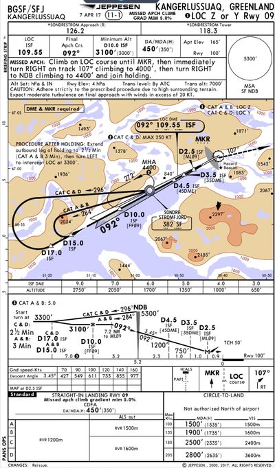
Landing Kangerlussuaq gave us a chance to fly the LOC 09 approach. At first glance, it looks pretty straight-forward. However, there is one small trick. Note that the final approach fix is at D10.0 from ISF (the LOC DME). So far, so good. But now look where the plate depicts the point where the 3.45° descent begins; it is 7.2NM to ML09, NOT to the LOC DME. ML09 is 2.5NM from the LOC DME. So, if you wanted to begin your descent at that point, you'd have to do some quick mental math. If you didn't see that small detail, it would be very easy to begin the descent too late, leaving you 1000' + above the runway threshold when you get to the MAP. There's 9,220' of runway here but you wouldn't really want to dive in from the MAP.